First Public Hearing is June 29
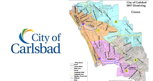
Carlsbad CA— Maps created by professional demographers and submitted by members of the public for Carlsbad’s upcoming change to “by district” City Council elections are available for review. See them on the city’s website or get copies at City Hall and other facilities. The first of two public hearings to gather input on the draft maps will be held Thursday, June 29, starting at 6 p.m., City Hall, 1200 Carlsbad Village Drive.
The city’s demographer provided three map options, and members of the public submitted eight four-district maps with an at large mayor. Last week, the Carlsbad City Council voted to keep the position of mayor “at large,” meaning all city voters will continue to elect the mayor, while Council members will be elected by districts.
The city provided a number of ways to provide input into the map-making process, including two public hearings and two hands-on workshops with the demographer. Map making kits were available on the city website and at city facilities, and an online mapping tool was available for those wanting to create more detailed proposals.
“Residents have great ideas, and often draw things we wouldn’t have thought of,” said Douglas Johnson, president and founder of National Demographics Corporation, the company hired by the city to assist with the transition to electing City Council members by district. “We know the legal criteria, but residents provide local knowledge and history, which are also important.”
Johnson said his company took into account the comments and maps submitted by residents in creating the draft maps his company submitted.
To comment on the draft maps, residents have several options:
- Attend public hearings June 29 and July 11, both starting at 6p.m. in the City Council chamber, 1200 Carlsbad Village Drive.
- Mark up paper maps with comments and submit to the city’s demographer or the City Clerk’s Office.
- Use the online mapping tool to suggest alternative maps based on the drafts.
“What is most helpful to us is hearing the reasons why people do or don’t like the draft maps,” said Johnson. “The more specific, the better.”
The criteria for creating district boundaries include:
- Each Council district shall contain a nearly equal population as required by law.
- Council district borders shall be drawn in a manner that complies with the Federal Voting Rights Act and avoids racial gerrymandering.
- Council districts shall consist of contiguous territory in as compact form as possible.
- Council districts shall respect “communities of interest” as much as possible (neighborhoods, school boundaries, common interests, etc.).
- Council district borders shall follow visible natural and man-made geographical and topographical features as much as possible.
- District borders shall be designed, insofar as this does not conflict with federal or state law, to respect the choices of the voters by avoiding the pairing of current Council members.
For more information about why the city is changing the way Council members are elected and other background information about district elections, visit www.carlsbadca.gov/districts.
Quick links
District election map information
Proposed election years sequencing
California Voting Rights Act
California Voting Rights Act “Safe Harbor” provision
Federal Voting Rights Act
April 5, 2017 “demand letter” alleging violation of the California Voting Rights Act
May 9 staff report recommending a resolution to change to electing City Council members by district
May 30 staff report to hold a public hearing for input on district composition and adopt a resolution setting forth legal criteria for district boundaries
June 13 staff report (starts on pg. 565) to hold a public hearing on district composition


